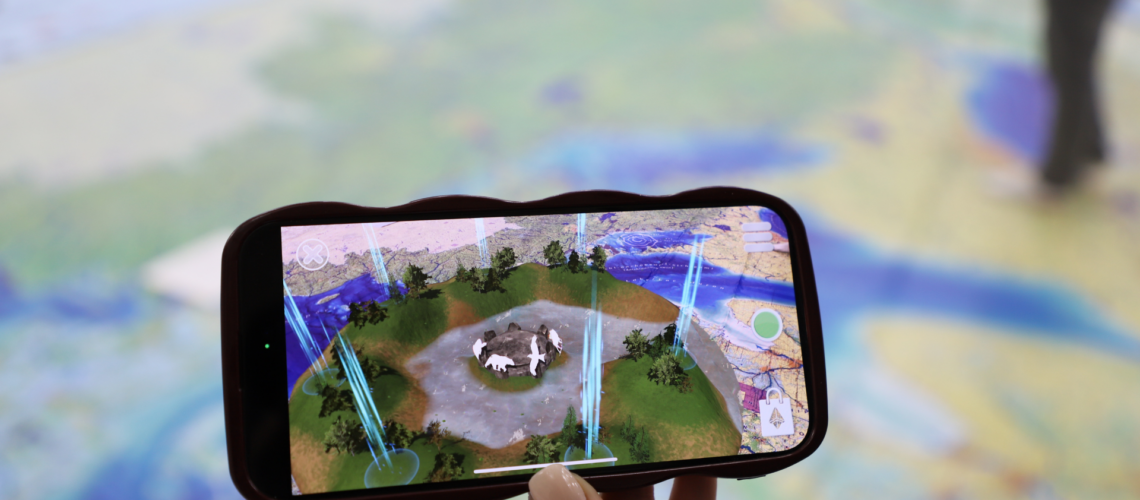
Students and community members gathered at Algoma University’s George Leach Centre on Monday, April 7, for a unique and immersive educational experience focused on Great Lakes water protection. Presented through a Special Topics course offered by the Department of Biology, the event featured Biinaagami—an 8m x 11m floor map developed by Canadian Geographic. The map provided a striking visual representation of the Great Lakes Basin, enhanced by interactive Augmented Reality (AR) elements that brought environmental and cultural insights to life.
The display encouraged participants to explore the interconnected systems of the watershed while engaging with important themes of environmental stewardship, Indigenous knowledge, and clean water advocacy. The map’s title, Biinaagami, translates to “pure clean water,” reflecting the project’s core message. Participants had the opportunity to bring the map to life using the Biinaagami AR app, interacting with cultural, ecological, and scientific layers using their mobile devices and earphones.
“As hopefully everyone knows, the Great Lakes contain 20 percent of the world’s surface fresh water and serve both water supply and waste disposal services for over 38 million residents in Canada, the United States, and over 125 Indigenous nations in the watershed,” said Professor Michael Twiss, the course instructor. “Our relationship with the Great Lakes has brought with it social benefits and environmental costs. In the past decades, there has been notable success controlling environmental consequences of development, such as suppression of sea lamprey, yet we are faced with emerging issues like ‘forever’ chemicals that are invading our waters.”
The map was previously featured at the Anishinabek Nation Water Consortium in Little Current, where it was also celebrated for its potential to bridge traditional knowledge with modern technology in meaningful ways.
To view photos from the event, click here.
For more information about the Biinaagami project, visit: https://biinaagami.org
Additional Quotes
“Canadian Geographic has worked collaboratively with many partners to offer a truly unique way for students from across the watershed to explore and experience the Great Lakes-St. Lawrence watershed. The Biinaagami Giant Floor Map education kit is available for educators to book, free of charge and comes with bilingual, curriculum-based lesson plans and augmented reality stories, always emphasizing a two-eyed seeing perspective. These resources are set to enrich schools and communities across the watershed, fostering a new generation of water protectors. We’ve got a diverse team of storytellers who are consistently telling new stories through video, film, augmented reality, cartography and magazine articles. I encourage everyone to learn more at Biinaagami.org and follow us on social media.”
- Meredith Brown, Director of Water and Land Relations, Canadian Geographic
“The Anji inaashkawun (Waves of Change) team, part of the BRIDGE Lab, focuses on freshwater research and stewardship in the Algoma region. Using innovative tools like the Giant Floor Map – Biinaagami with Augmented Reality, the project integrates Indigenous and Western knowledge systems through mixed-methods research. It emphasizes sustainable solutions, meaningful partnerships, and intergenerational learning to address freshwater challenges holistically.”
- Indigenous Liaison, Amber McKay
Share Article